Transport systems across Asia and the Pacific are increasingly exposed to climate-related hazards, particularly flooding. Understanding where transport infrastructure is vulnerable is becoming an important step toward strengthening resilience and supporting climate-informed planning.
Since the turn of the century, 65% of all global geophysical disasters, more than 40% hydrological and meteorological disasters, and a fourth of all climatological disasters have occurred in the Asia-Pacific (Centre for Research on the Epidemiology of Disasters, 2025)
The quality or transport infrastructure is still poor in low and lower middle-income countries, most of which have a transport quality rating between 2 and 3 (out of 5) compared to ratings of 3 or higher for most high-income countries in the Asia-Pacific and for Europe and North America. This is despite improvements in ratings of up to 55% between 2007 and 2022. Asia and the Pacific accounts for 65% of the globally expected annual direct physical damages to transport infrastructure due to climate and various other hazards.
Through the support of the European Space Agency (ESA) and the Asian Development Bank (ADB), through the Global Development Assistance Program- a global partnership to mainstream the use of Earth Observation into development operations as a catalyst for long-term action- the Asian Transport Observatory (ATO) has collaborated with iABG, to develop a prototype tool to assess and visualize the flood exposure of road networks in the region.
This "Climate Exposure Dashboard for Transport" prototype demonstrates how earth observation data can be combined with open geospatial datasets to evaluate potential exposure of transport networks. The tool overlays flood hazard information with road network data to visualize where major road infrastructure—particularly motorways—intersects with flood-prone areas.
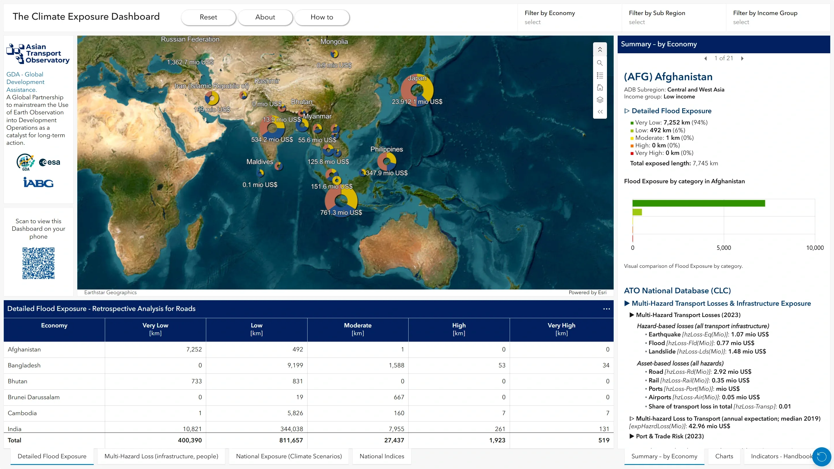
The analysis utilizes earth observation and open geospatial datasets, and applies a standardized methodology across countries. This includes harmonized geospatial processing and consistent weighting approaches when aggregating exposure indicators.
The tool provides a first illustration of how integrated geospatial data can help identify infrastructure segments potentially at risk from flooding. Such insights can support governments, development partners, and infrastructure planners in:
- identifying priority corridors for resilience investments
- benchmarking their country's road transport systems with others in terms of exposure to climate hazards
- understanding the relative distribution of the road network when it comes to hazard exposure
- supporting data-driven planning for climate-resilient infrastructure
The prototype represents an initial step toward integrating earth observation data into transport resilience monitoring for the region. Future work will explore expanding the approach to additional countries, infrastructure types, and hazard datasets. The prototype is built on a scalable platform which enables the integration of other thematic layers (e.g. other types of hazards, global layers), other transport network assets (e.g. railways, ports, airports), and other indicators.
The prototype tool has been launched during the EST Regional Meeting and Capacity-Building Workshop towards Accelerating Implementation of the Aichi 2030 Declaration (2021-2030) in Bangkok this March 2026.
Explore the tool here: https://experience.arcgis.com/experience/4ad6cb618f8544b4b3653229b5a42abc